
A powerful winter storm is bringing extreme weather to the Upper Midwest, Great Lakes, and Northeast this weekend.
According to the National Weather Service, the system is intensifying as it moves east, producing heavy snow, whiteout conditions, dangerous ice, and bitter wind chills across the Upper Midwest, Great Lakes, and Northeast.
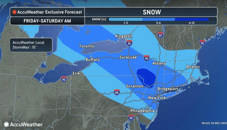
Forecasts warn of more than a foot of snow in parts of Michigan’s Upper Peninsula, lake‑effect snow in western New York and northwest Pennsylvania, and ice accumulations up to a quarter‑inch in areas of New York, Connecticut, and Massachusetts
The condition is expected to intensify over the next few days through Tuesday.
“Arctic air will descend into the Plains beginning Sunday followed by a potent winter storm across the upper Midwest to the Great Lakes Sunday night to Monday,” according to a bulletin from the NWS posted on Saturday.
With winter weather ended over New England this afternoon, much of our attention will turn westward to the Plains and Upper Midwest as a compact upper-trough analyzed over the Northern Rockies displaces a frigid Arctic airmass southward. In turn, the next big storm system is forecast to rapidly intensify along the Arctic front over the Midwest tomorrow, before tracking through the Great Lakes on Monday.
Heavy snow and whiteout conditions are forecasted across parts of the Upper Midwest and Great Lakes region, causing “treacherous travel,” the NWS said. More than a foot of snow could fall along Michigan’s Upper Peninsula. Western New York and Northwest Pennsylvania are expected to receive lake-effect snow.
The storm has slammed the Northeast, dumping up to nearly 8 inches of snow on New York City and surrounding areas between Friday and Saturday. The weather snarled traffic along the I-95 corridor and disrupted air travel. Flight tracker, Flightaware.com, showed more than 1,000 delays across U.S. airports on Saturday evening. Nearly 1,000 flights were cancelled into, out of and within the U.S. as of Saturday evening.

The NWS is also warning of dangerous ice across parts of the Northeast, including ice accumulation of up to a quarter of an inch in eastern New York, parts of Connecticut and Massachusetts. Bitter wind chills as low as -35 degrees are expected in parts of North Dakota and up to -25 degrees in northern Minnesota.

Meanwhile, it will feel more like spring across parts of the South and into the Tennessee Valley, where temperatures could reach highs in the 70s for this time of year, according to forecasters.

